


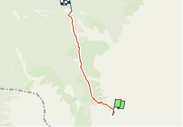

3.6 km | 7.6 km-effort


Tous les sentiers balisés d’Europe PRO


FREE GPS app for hiking
 SityTrail
IGN / Geographical institutes
SityTrail World
The world is yours!
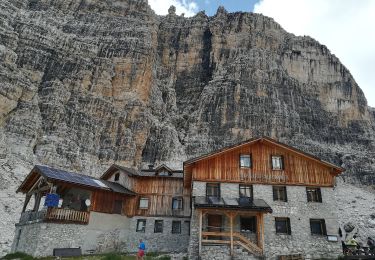
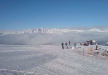
Trail On foot of 3.5 km to be discovered at Trentino-Alto Adige/Südtirol, Provincia di Trento, Tre Ville. This trail is proposed by SityTrail - itinéraires balisés pédestres.
Trail created by Società degli Alpinisti Tridentini.
Website: http://www.sat.tn.it/
 "
data-pinterest-text="Pin it"
data-tweet-text="share on twitter"
data-facebook-share-url="https://www.sitytrail.com/en/trails/3112331-tre-ville--sentiero-attrezzato-xriccardo-violix/?photo=1#lg=1&slide=1"
data-twitter-share-url="https://www.sitytrail.com/en/trails/3112331-tre-ville--sentiero-attrezzato-xriccardo-violix/?photo=1#lg=1&slide=1"
data-googleplus-share-url="https://www.sitytrail.com/en/trails/3112331-tre-ville--sentiero-attrezzato-xriccardo-violix/?photo=1#lg=1&slide=1"
data-pinterest-share-url="https://www.sitytrail.com/en/trails/3112331-tre-ville--sentiero-attrezzato-xriccardo-violix/?photo=1#lg=1&slide=1">
"
data-pinterest-text="Pin it"
data-tweet-text="share on twitter"
data-facebook-share-url="https://www.sitytrail.com/en/trails/3112331-tre-ville--sentiero-attrezzato-xriccardo-violix/?photo=1#lg=1&slide=1"
data-twitter-share-url="https://www.sitytrail.com/en/trails/3112331-tre-ville--sentiero-attrezzato-xriccardo-violix/?photo=1#lg=1&slide=1"
data-googleplus-share-url="https://www.sitytrail.com/en/trails/3112331-tre-ville--sentiero-attrezzato-xriccardo-violix/?photo=1#lg=1&slide=1"
data-pinterest-share-url="https://www.sitytrail.com/en/trails/3112331-tre-ville--sentiero-attrezzato-xriccardo-violix/?photo=1#lg=1&slide=1">
 "
data-pinterest-text="Pin it"
data-tweet-text="share on twitter"
data-facebook-share-url="https://www.sitytrail.com/en/trails/3112331-tre-ville--sentiero-attrezzato-xriccardo-violix/?photo=2#lg=1&slide=2"
data-twitter-share-url="https://www.sitytrail.com/en/trails/3112331-tre-ville--sentiero-attrezzato-xriccardo-violix/?photo=2#lg=1&slide=2"
data-googleplus-share-url="https://www.sitytrail.com/en/trails/3112331-tre-ville--sentiero-attrezzato-xriccardo-violix/?photo=2#lg=1&slide=2"
data-pinterest-share-url="https://www.sitytrail.com/en/trails/3112331-tre-ville--sentiero-attrezzato-xriccardo-violix/?photo=2#lg=1&slide=2">
"
data-pinterest-text="Pin it"
data-tweet-text="share on twitter"
data-facebook-share-url="https://www.sitytrail.com/en/trails/3112331-tre-ville--sentiero-attrezzato-xriccardo-violix/?photo=2#lg=1&slide=2"
data-twitter-share-url="https://www.sitytrail.com/en/trails/3112331-tre-ville--sentiero-attrezzato-xriccardo-violix/?photo=2#lg=1&slide=2"
data-googleplus-share-url="https://www.sitytrail.com/en/trails/3112331-tre-ville--sentiero-attrezzato-xriccardo-violix/?photo=2#lg=1&slide=2"
data-pinterest-share-url="https://www.sitytrail.com/en/trails/3112331-tre-ville--sentiero-attrezzato-xriccardo-violix/?photo=2#lg=1&slide=2">
 "
data-pinterest-text="Pin it"
data-tweet-text="share on twitter"
data-facebook-share-url="https://www.sitytrail.com/en/trails/3112331-tre-ville--sentiero-attrezzato-xriccardo-violix/?photo=3#lg=1&slide=3"
data-twitter-share-url="https://www.sitytrail.com/en/trails/3112331-tre-ville--sentiero-attrezzato-xriccardo-violix/?photo=3#lg=1&slide=3"
data-googleplus-share-url="https://www.sitytrail.com/en/trails/3112331-tre-ville--sentiero-attrezzato-xriccardo-violix/?photo=3#lg=1&slide=3"
data-pinterest-share-url="https://www.sitytrail.com/en/trails/3112331-tre-ville--sentiero-attrezzato-xriccardo-violix/?photo=3#lg=1&slide=3">
"
data-pinterest-text="Pin it"
data-tweet-text="share on twitter"
data-facebook-share-url="https://www.sitytrail.com/en/trails/3112331-tre-ville--sentiero-attrezzato-xriccardo-violix/?photo=3#lg=1&slide=3"
data-twitter-share-url="https://www.sitytrail.com/en/trails/3112331-tre-ville--sentiero-attrezzato-xriccardo-violix/?photo=3#lg=1&slide=3"
data-googleplus-share-url="https://www.sitytrail.com/en/trails/3112331-tre-ville--sentiero-attrezzato-xriccardo-violix/?photo=3#lg=1&slide=3"
data-pinterest-share-url="https://www.sitytrail.com/en/trails/3112331-tre-ville--sentiero-attrezzato-xriccardo-violix/?photo=3#lg=1&slide=3">
 "
data-pinterest-text="Pin it"
data-tweet-text="share on twitter"
data-facebook-share-url="https://www.sitytrail.com/en/trails/3112331-tre-ville--sentiero-attrezzato-xriccardo-violix/?photo=4#lg=1&slide=4"
data-twitter-share-url="https://www.sitytrail.com/en/trails/3112331-tre-ville--sentiero-attrezzato-xriccardo-violix/?photo=4#lg=1&slide=4"
data-googleplus-share-url="https://www.sitytrail.com/en/trails/3112331-tre-ville--sentiero-attrezzato-xriccardo-violix/?photo=4#lg=1&slide=4"
data-pinterest-share-url="https://www.sitytrail.com/en/trails/3112331-tre-ville--sentiero-attrezzato-xriccardo-violix/?photo=4#lg=1&slide=4">
"
data-pinterest-text="Pin it"
data-tweet-text="share on twitter"
data-facebook-share-url="https://www.sitytrail.com/en/trails/3112331-tre-ville--sentiero-attrezzato-xriccardo-violix/?photo=4#lg=1&slide=4"
data-twitter-share-url="https://www.sitytrail.com/en/trails/3112331-tre-ville--sentiero-attrezzato-xriccardo-violix/?photo=4#lg=1&slide=4"
data-googleplus-share-url="https://www.sitytrail.com/en/trails/3112331-tre-ville--sentiero-attrezzato-xriccardo-violix/?photo=4#lg=1&slide=4"
data-pinterest-share-url="https://www.sitytrail.com/en/trails/3112331-tre-ville--sentiero-attrezzato-xriccardo-violix/?photo=4#lg=1&slide=4">
 "
data-pinterest-text="Pin it"
data-tweet-text="share on twitter"
data-facebook-share-url="https://www.sitytrail.com/en/trails/3112331-tre-ville--sentiero-attrezzato-xriccardo-violix/?photo=5#lg=1&slide=5"
data-twitter-share-url="https://www.sitytrail.com/en/trails/3112331-tre-ville--sentiero-attrezzato-xriccardo-violix/?photo=5#lg=1&slide=5"
data-googleplus-share-url="https://www.sitytrail.com/en/trails/3112331-tre-ville--sentiero-attrezzato-xriccardo-violix/?photo=5#lg=1&slide=5"
data-pinterest-share-url="https://www.sitytrail.com/en/trails/3112331-tre-ville--sentiero-attrezzato-xriccardo-violix/?photo=5#lg=1&slide=5">
"
data-pinterest-text="Pin it"
data-tweet-text="share on twitter"
data-facebook-share-url="https://www.sitytrail.com/en/trails/3112331-tre-ville--sentiero-attrezzato-xriccardo-violix/?photo=5#lg=1&slide=5"
data-twitter-share-url="https://www.sitytrail.com/en/trails/3112331-tre-ville--sentiero-attrezzato-xriccardo-violix/?photo=5#lg=1&slide=5"
data-googleplus-share-url="https://www.sitytrail.com/en/trails/3112331-tre-ville--sentiero-attrezzato-xriccardo-violix/?photo=5#lg=1&slide=5"
data-pinterest-share-url="https://www.sitytrail.com/en/trails/3112331-tre-ville--sentiero-attrezzato-xriccardo-violix/?photo=5#lg=1&slide=5">
 "
data-pinterest-text="Pin it"
data-tweet-text="share on twitter"
data-facebook-share-url="https://www.sitytrail.com/en/trails/3112331-tre-ville--sentiero-attrezzato-xriccardo-violix/?photo=6#lg=1&slide=6"
data-twitter-share-url="https://www.sitytrail.com/en/trails/3112331-tre-ville--sentiero-attrezzato-xriccardo-violix/?photo=6#lg=1&slide=6"
data-googleplus-share-url="https://www.sitytrail.com/en/trails/3112331-tre-ville--sentiero-attrezzato-xriccardo-violix/?photo=6#lg=1&slide=6"
data-pinterest-share-url="https://www.sitytrail.com/en/trails/3112331-tre-ville--sentiero-attrezzato-xriccardo-violix/?photo=6#lg=1&slide=6">
"
data-pinterest-text="Pin it"
data-tweet-text="share on twitter"
data-facebook-share-url="https://www.sitytrail.com/en/trails/3112331-tre-ville--sentiero-attrezzato-xriccardo-violix/?photo=6#lg=1&slide=6"
data-twitter-share-url="https://www.sitytrail.com/en/trails/3112331-tre-ville--sentiero-attrezzato-xriccardo-violix/?photo=6#lg=1&slide=6"
data-googleplus-share-url="https://www.sitytrail.com/en/trails/3112331-tre-ville--sentiero-attrezzato-xriccardo-violix/?photo=6#lg=1&slide=6"
data-pinterest-share-url="https://www.sitytrail.com/en/trails/3112331-tre-ville--sentiero-attrezzato-xriccardo-violix/?photo=6#lg=1&slide=6">
 "
data-pinterest-text="Pin it"
data-tweet-text="share on twitter"
data-facebook-share-url="https://www.sitytrail.com/en/trails/3112331-tre-ville--sentiero-attrezzato-xriccardo-violix/?photo=7#lg=1&slide=7"
data-twitter-share-url="https://www.sitytrail.com/en/trails/3112331-tre-ville--sentiero-attrezzato-xriccardo-violix/?photo=7#lg=1&slide=7"
data-googleplus-share-url="https://www.sitytrail.com/en/trails/3112331-tre-ville--sentiero-attrezzato-xriccardo-violix/?photo=7#lg=1&slide=7"
data-pinterest-share-url="https://www.sitytrail.com/en/trails/3112331-tre-ville--sentiero-attrezzato-xriccardo-violix/?photo=7#lg=1&slide=7">
"
data-pinterest-text="Pin it"
data-tweet-text="share on twitter"
data-facebook-share-url="https://www.sitytrail.com/en/trails/3112331-tre-ville--sentiero-attrezzato-xriccardo-violix/?photo=7#lg=1&slide=7"
data-twitter-share-url="https://www.sitytrail.com/en/trails/3112331-tre-ville--sentiero-attrezzato-xriccardo-violix/?photo=7#lg=1&slide=7"
data-googleplus-share-url="https://www.sitytrail.com/en/trails/3112331-tre-ville--sentiero-attrezzato-xriccardo-violix/?photo=7#lg=1&slide=7"
data-pinterest-share-url="https://www.sitytrail.com/en/trails/3112331-tre-ville--sentiero-attrezzato-xriccardo-violix/?photo=7#lg=1&slide=7">
 "
data-pinterest-text="Pin it"
data-tweet-text="share on twitter"
data-facebook-share-url="https://www.sitytrail.com/en/trails/3112331-tre-ville--sentiero-attrezzato-xriccardo-violix/?photo=8#lg=1&slide=8"
data-twitter-share-url="https://www.sitytrail.com/en/trails/3112331-tre-ville--sentiero-attrezzato-xriccardo-violix/?photo=8#lg=1&slide=8"
data-googleplus-share-url="https://www.sitytrail.com/en/trails/3112331-tre-ville--sentiero-attrezzato-xriccardo-violix/?photo=8#lg=1&slide=8"
data-pinterest-share-url="https://www.sitytrail.com/en/trails/3112331-tre-ville--sentiero-attrezzato-xriccardo-violix/?photo=8#lg=1&slide=8">
"
data-pinterest-text="Pin it"
data-tweet-text="share on twitter"
data-facebook-share-url="https://www.sitytrail.com/en/trails/3112331-tre-ville--sentiero-attrezzato-xriccardo-violix/?photo=8#lg=1&slide=8"
data-twitter-share-url="https://www.sitytrail.com/en/trails/3112331-tre-ville--sentiero-attrezzato-xriccardo-violix/?photo=8#lg=1&slide=8"
data-googleplus-share-url="https://www.sitytrail.com/en/trails/3112331-tre-ville--sentiero-attrezzato-xriccardo-violix/?photo=8#lg=1&slide=8"
data-pinterest-share-url="https://www.sitytrail.com/en/trails/3112331-tre-ville--sentiero-attrezzato-xriccardo-violix/?photo=8#lg=1&slide=8">
 "
data-pinterest-text="Pin it"
data-tweet-text="share on twitter"
data-facebook-share-url="https://www.sitytrail.com/en/trails/3112331-tre-ville--sentiero-attrezzato-xriccardo-violix/?photo=9#lg=1&slide=9"
data-twitter-share-url="https://www.sitytrail.com/en/trails/3112331-tre-ville--sentiero-attrezzato-xriccardo-violix/?photo=9#lg=1&slide=9"
data-googleplus-share-url="https://www.sitytrail.com/en/trails/3112331-tre-ville--sentiero-attrezzato-xriccardo-violix/?photo=9#lg=1&slide=9"
data-pinterest-share-url="https://www.sitytrail.com/en/trails/3112331-tre-ville--sentiero-attrezzato-xriccardo-violix/?photo=9#lg=1&slide=9">
"
data-pinterest-text="Pin it"
data-tweet-text="share on twitter"
data-facebook-share-url="https://www.sitytrail.com/en/trails/3112331-tre-ville--sentiero-attrezzato-xriccardo-violix/?photo=9#lg=1&slide=9"
data-twitter-share-url="https://www.sitytrail.com/en/trails/3112331-tre-ville--sentiero-attrezzato-xriccardo-violix/?photo=9#lg=1&slide=9"
data-googleplus-share-url="https://www.sitytrail.com/en/trails/3112331-tre-ville--sentiero-attrezzato-xriccardo-violix/?photo=9#lg=1&slide=9"
data-pinterest-share-url="https://www.sitytrail.com/en/trails/3112331-tre-ville--sentiero-attrezzato-xriccardo-violix/?photo=9#lg=1&slide=9">


On foot

On foot

On foot

On foot

On foot

On foot
On foot
On foot

On foot